One mountain valley.
One emitting factory.
A hypothetical factory is placed on a gentle mountain cell at the original selected mountain site, with its new model-ground height measured from the refined grid. Only its single76.2m stack emits SO2. All original source emissions and initial background are excluded. The same r04 equations, wind varying with height, integral thermal rise and volume renderer are retained. Twelve hours of weather adjustment precede24 hours of continuous source transport.
Terrain seed42
Continuous source period24 h
Terrain maximum4,096 m
Native surface maximum81.664 ppb
Display-region rain total9.558 mm
Actual source particles300,000
Source increments only; background is excluded. These are model-layer/cell means, not observed exposure measurements. The surface maximum is selected across all24 hourly native frames and the full regional grid.
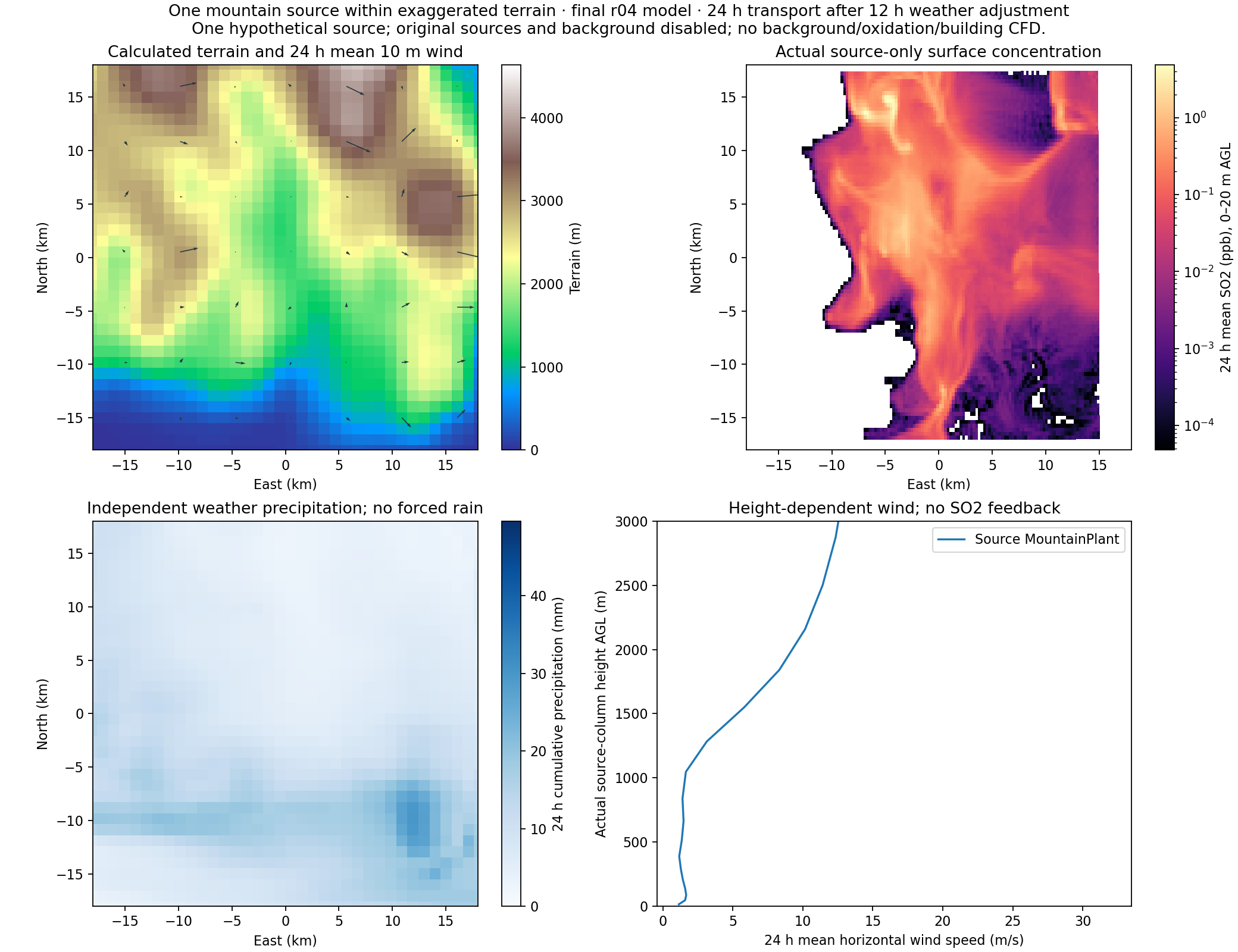 Actual new case fields. White concentration cells are zero. Native grids are shown without artificial texture detail.
Actual mass budget
Global native accounting in kg, including transport outside the displayed regional box. No age termination, hidden deletion or background mass. Total residual: -1.737e-07 kg.
How it was calculated
Terrain
Seed42 determines the previously qualified artificial mountain geometry. That physical3km HGT is bilinearly sampled on the new1km weather grid, without another physical uplift or invented fine-scale terrain. Only the webpage ground altitude display is doubled from3x to6x; stack and plume heights above ground retain3x. New native real recalculates terrain-following IC/BC on local3km/1km domains from the same frozenGFS. This does not increase the information resolution of the source terrain.
One continuous day
Weather begins4 Nov2026 at18:00 UTC. Source transport runs5 Nov06:00 to6 Nov06:00 UTC after12 h adjustment. New parent/child integration steps are3/1s, with epssm=0.5 acoustic time off-centering after explicit stability tests. The physical parameterizations are retained; new terrain-balanced IC/BC and local boundary positions are recomputed on the refined grids. The same frozen GFS scenario is reused; this is not a current geographic forecast.
Passive three-dimensional transport
The resolved u,v,w vary horizontally, vertically and with time. FLEXPART supplies its native stochastic turbulence. SO2 has no wind feedback. The same50-level physical model runs on new3/1 km local grids; this is not building CFD or the unqualified5 m LES.
Finite-density thermal rise
M is carrier mass flux (kg/s), b plume radius (m), rho air density (kg/m3), v carrier velocity and n its unit axis. This is the final website integral entrainment closure; its coefficients were not fitted to this terrain.
Momentum and heat
Particles originate on the specified outlet disks. The integral solution supplies parameterized buoyant displacement/spread while native transport uses the actual wind. It is one-way parameterized heat/entrainment, not resolved hot-jet flow.
Mass accounting
All24 actual hourly fields pass finite/nonnegative pollution, exact ZERO and native global budget checks. Regional cumulative deposition never exceeds the global deposition ledger. Tiny negative weather condensate traces remain unmodified. The near-field inside-mass diagnostic now groups accepted quadrature weights once per call, retaining the original mass tolerance, cell concentration accumulation and particle physics. A real failed-state control rejected the old rounded counter and accepted the callwise counter; the exported cell concentrations were bit-identical in that control.
Native units
Surface queries use the actual0–20 m layer means. Cumulative deposition is the final snapshot, not a sum of snapshots. Full-period means average24 actual one-hour intervals.
Scalar playback
Twenty-four physical hours play in15 seconds by default. The3D viewer reconstructs decoded concentration with shape-preserving cubic Hermite interpolation: harmonic neighbouring slopes give continuous change rates at hourly knots, with zero slope at a genuine local extremum and no overshoot. Original hourly samples, native surface queries and Scientific analysis remain unchanged. This is display reconstruction, not newly computed sub-hourly transport. Scalar textures are uploaded before playback; rendered images are never crossfaded or RGB-blended.
What remains approximate
Only one hypothetical mountain source is active. Its76.2m outlet and343.2877kg/day numerical emission prior are inherited from the reviewed2024 FCC template, not actual emissions at this mountain location. Original water, land-cover and soil fields are retained in the exaggerated terrain weather. The source remains at its originally selected geographic location; it does not feed back into the newly integrated weather. Visible mountains use native model-ground with bilinear subdivision; original building geometry is redraped onto it. The schematic level factory pad affects display geometry only. The1km WRF and native FLEX terrain grids use different interpolation. Their actual ground heights at the outlet are provided in the numerical-results JSON; the display base follows native FLEX ground without altering physical inputs. Surface queries are native0–20m AGL layer means. Individual building wakes are not resolved. The same private WRF-compatible JAX implementation, Noah-MP4 and native CPU FLEXPART are used. GPU weather and batched plume integration do not make the whole chain GPU-only.
The1 km weather grid and parameterized turbulence cannot resolve individual building wakes or small eddies. Fine96³ residence bins do not establish near-nozzle engineering accuracy or particle convergence. Twelve-hour adjustment is not proof of complete spinup. SO2 oxidation and background inflow are absent. Prior2 mm GPU/CPU consistency evidence is not a synthetic-terrain observation-error bound.
Data and code
Full shared model methods and earlier qualification evidence ↗